|
Maps & Documents |
| |
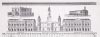
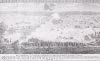
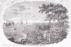
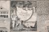
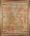   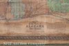 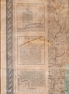 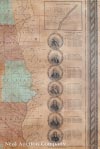 | Monumental Map of Alabama and West Florida by John La Tourrette (American, b. 1785), "An Accurate Map of the State of Alabama and West Florida: Carefully compiled from the original surveys of the General Government; designed to exhibit at one view each Section and Fractional Section, so that each person can point to the tract on which he lives; By John La Tourrette, Mobile, Ala.", Engraved by S. Stiles & Co, New York, 1837, hand‑colored wall map, first state, with vignettes of The State House, A Cotton Plant, University of the State of Alabama, The U.S. Arsenal and Fort Morgan; inset maps of Mobile, Florence, Tuscaloosa, Tuscumbia, Huntsville, Montgomery, Wetumpka and Pensacola; and numerous economic and demographic charts, sheet 66 in. x 54 in., framed, original rollers unmounted but provided. Sold on February 11, 2017 for
$42,700.00 |


|
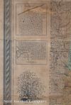
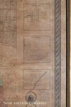
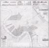
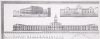
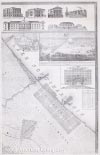
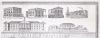
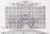
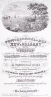
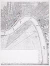
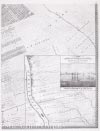
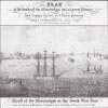
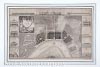
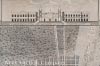
Charles F. Zimpel (Prussian/American, 1801‑1879),
"Topographical Map of New Orleans and its Vicinity,
Embracing a distance of twelve miles up and eight and three
quarter miles down the Mississippi River and Part of Lake
Pontchartrain, representing all Public Improvements existing
and projected and important Establishments, accompanied by A
Statistical Table, containing the most accurate
Illustrations; prefaced by A Splendid View of New Orleans, &
Compiled from actual surveys and the best authorities, by
Chas. F. Ximpel, Deputy City Surveyor of New Orleans, Chief
Engineer of the New Orleans & Carrollton Rail Road Company
and late Engineer in the Prussian Service, Scale six inches
to the mile, New Orleans March 1834", lithograph, on six
sheets, original folio, vignettes showing: Orleans Cotton
Press Co., City Hotel, Levee Steam Cotton Press, City Hall (Cabildo),
St. Louis Cathedral, Presbytere, Bank of the Canal and
Banking Co., City House and Market of the City of Lafayette,
Bank of New Orleans, Union Bank, American Theater, Sugar
Refinery, Charity Hospital, State House, "Defeat of the
British Army...", "Plan of the Banks of the Mississippi and
Adjacent Country...", and "Mouth of the Mississippi at the
South West Pass", six sheets (combined) 63 in. x 64 in.
Sold on November 18, 2017 for $39,650.00
|
   |
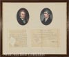
Rare Pair of Documents Signed by Explorers William Clark and Meriwether Lewis, the first, a manuscript Justice of the Peace appointment of H.M. Guyol, signed "William Clark", as Governor of Missouri Territory, St. Louis Oct. 10th 1817, with paper seal, 7 3/4 in. x 7 1/2 in.; the second a partially‑printed appointment of Thomas Oliver as Judge Advocate of the 2d Regiment of Militia, 1809, signed "Meriwether Lewis" as Governor and Commander in Chief of the Territory of Louisiana, with paper seal, 7 3/4 in. x 12 1/2 in., framed together with portraits after the paintings of Charles Wilson Peale.
Sold for $21,960.00 on November 23, 2019. |
     |
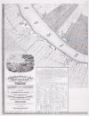
Jacques Tanesse (New Orleans), "Plan of the City and Suburbs of New Orleans from an Actual Survey made in 1815 by J. Tanesse, City Surveyor", 1817, engraving, drawn by Jacques Tanesse, engraved by William Rollinson, published by Charles del Vecchio, N.Y., and Pierre Maspero, New Orleans, sheet 20 1/2 in. x 31 in., framed. Sold on March 24, 2018 for $18,300.00 |
|

|
|